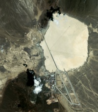
Area 51
Revision as of 00:56, 13 March 2009 by Lafayette1 (talk | contribs) (New page: {{Infobox Airport |name ='''Area 51''' |nativename = |nativename-a = |nativename-r = |image =Area_51.jpg |image-width = |caption =This satellite image of Area 51 sh...)
| Area 51 | |||
|---|---|---|---|
| |||
| IATA: GRM – ICAO: KGRM | |||
| Summary | |||
| Airport type | Military | ||
| Operator | United States Air Force | ||
| Location | Southern Nevada, United States | ||
| Elevation AMSL | 4462 ft / 1360 m | ||
| Coordinates | 37°14′06″N 115°48′40″W | ||
| Runways | |||
| Direction | Length | Surface | |
| ft | m | ||
| 14L/32R | 12,000 | 3,658 | Asphalt |
| 14R/32L | 23,270 | 7,093 | Asphalt |
| 12/30 | 5,420 | 1,652 | Asphalt |
| 09L/27R | 11,440 | 3,489 | Salt |
| 09R/27L | 11,440 | 3,489 | Salt |
| 03L/21R | 10,030 | 3,057 | Salt |
| 03R/21L | 10,030 | 3,057 | Salt |
